MONOJ GOGOI
Early warning can minimize the devastation of flash flood
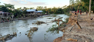
DHEMAJI, OCT 3: The frequency and intensity of flash flood is rapidly and noticeably increasing year by year in the eastern parts of Assam and Arunachal Pradesh, particularly in the districts of Assam’s Lakhimpur and Dhemaji and Arunachal Pradesh’s Lohit, Lower Subansiri and Anjaw districts. Many people believe that the root cause of this rapid increase of flash flood in this region may be attributed mainly to erratic rainfall in the upper catchment areas due to climate change or climate variability. The flash flood is different than the normal monsoon flood as it carries huge amount of water loaded with debris and sediment to the plains affecting people, livestock, crops land etc. The energetic flash flood is difficult to deal with and more hazardous than a typical monsoon flood because of its suddenness without giving much indication before. The north bank tributaries of the Brahmaputra are flashier and more prone to the flash flood for high gradients. River researchers believe that the devastation of such flood could be minimized by effective flood forecast and early warning system.
Dr. Partha J Das, a river researcher and a renowned environmentalist told this correspondent that in this context it was very important to monitor weather system, especially in synoptic situation that cause heavy rainfall in the upper catchment in Arunachal Pradesh hills as well as the geomorphological conditions in upper catchment. Based on such information forecast and warning of flash flood could be provided. He also suggested that with high resolution digital satellite real time data, it was highly possible to monitor the weather system and rainfall events and catchment condition even in inaccessible hilly terrains. Criticizing the present approach of the government to flood management he told it was reactive in nature. To deal with, possibilities such events, should be disseminated from the upstream to the potentially affected people in the downstream in the form of flood forecast and warning, especially for the north bank tributaries of Assam. While some amount of qualitative flood forecast was provided by the Central Water Commission (CWC) for the Brahmaputra, there was hardly any forecast or warning for its tributaries, he added.
It may be mentioned that a community based flood early warning system has been introduced experimentally in some of these rivers, particularly in the Jiadhal river in Dhemaji by Aaranyak, a Guwahati based biodiversity conservation NGO in collaboration with Kathmandu based ICIMOD over last few years. This system comprises of a simple flood gauge and a related instrument that produces a siren as water level rises in the river. And this flood warning is disseminated from the upstream to downstream through a community network using mobile phone. “This system of providing flood warning has become popular and useful to the community”, Jarman Doley, a flod affected of the Jiadal told. Harish Pegu, a flood control activist from Dhemaji told “It is very essential that government should promote such efforts and take up such effort on a larger scale in all the flashy rivers of the eastern Himalayan region.”

Comments
Post a Comment